Appendix B: A guide to subregion configuration based on drainage typology in the UNDO tool
Dividing a development into subregions, based on drainage type in the UNDO tool is relatively simple as long as the process is well understood. In most urban developments land-use categories will comprise a combination of:
- urban residential developments areas (which may include commercial or industrial areas)
- road reserves
- recreation and public open space
- possibly some larger lots zoned for rural living.
These land-use categories will rarely all have the same drainage type, and an UNDO project will probably require the development to be divided into subregions to represent each of the drainage types. For example, large lots associated with rural living areas do not generally pipe drainage water, and do not use subsoil drainage systems to control groundwater levels. Urban areas which use subsoil drains to control groundwater levels do not generally lay these subsoils drains beneath the public open space, and there are many combinations of road drainage network and urban drainage network – these range from full lot connections of the urban residential lot runoff to a piped road drainage network to the infiltration of all development water (negating the requirement for piping infrastructure completely). Many development areas use a combination of piped drainage network, a subsoil drainage network, and an open channel drainage network, so users of the UNDO tool may initially find it difficult to categorise the drainage type of their development. This section simplifies this process and provides a decision tree that will assist in creating subregions for their UNDO project based on the combination of drainage types for the development.
The decision tree (Figure B-1) leads the user to eight distinct drainage configurations. Each configuration is discussed in detail in the following sections, including an explanation of how to enter it into the UNDO tool, and where the types of configuration are generally used in south-west Western Australia. If a drainage configuration does not conform to any of these drainage types, the user is encouraged to consult the UNDO team for further advice (UNDO@water.wa.gov.au).
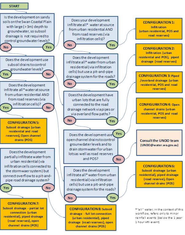
Figure B-1: Decision tree for configuring subregions based on drainage type for the UNDO tool
Configuration 1: Infiltration (road reserves, POS and urban residential)
Configuration 1: Infiltration systems are implemented in areas with sandy soils with sufficient depth to groundwater, where runoff from impervious surfaces from small rainfall events is infiltrated at source for road reserves, urban residential areas, and public open space. Runoff is infiltrated via infiltration cells, gardens and pervious paving for impervious roof and paving runoff for houses; roadside biofilters, tree-pits, pervious paving, swales and/or infiltration cells/trenches for road reserves; and infiltration basins, swales or biofilters for public open space. There is no connected stormwater system associated with a Configuration 1 drainage in UNDO. The conceptual model for Configuration 1 drainage is shown in Figure B-2.
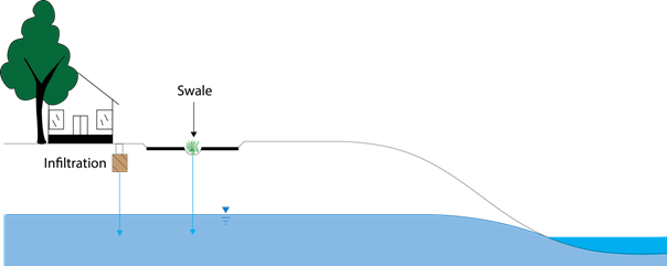
Figure B-2: Conceptual model for the drainage Configuration 1: Infiltration (road reserve, POS and urban residential)
Subregion configuration in the UNDO tool
It is possible for an entire development to be configured with only one subregion using a Configuration 1 (provided the soil type and fill properties are relatively consistent throughout the area). This is because the residential, road reserve and public open space areas can all be represented by this drainage type. If the development area varies significantly in terms of soil type, depth to groundwater or groundwater gradient, multiple subregions will be required.
General application of drainage type
Configuration 1 drainage occurs along the coastal strip of the Swan Coastal Plain where there is sufficient depth to groundwater. It is also present on the Swan Coastal Plain, north of Perth, where the Gnangara Mound provides adequate separation from groundwater for this type of drainage.
Configuration 2: Infiltration (urban residential and POS) and piped drainage (road reserve)
Configuration 2 drainage consists of infiltration systems for the urban residential allotments and piped drainage for the road reserve allotments. This is a fairly typical scenario for existing and new urban developments in deep groundwater regions of the northern Swan Coastal Plain (common along the coastal strip where there are large sand dunes associated with the Tamala Limestone/Spearwood Sands). Runoff generated by small rainfall events for urban allotments infiltrates via infiltration systems (e.g. soakwells) for the impervious area or direct infiltration from impervious areas. Runoff from road reserves is routed through pits and pipes located at road verges, and usually discharged to biofilters or infiltration basins. A conceptual diagram for Configuration 2 drainage is shown in Figure B-3.
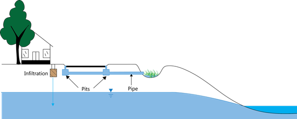
Figure B-3: Conceptual model for the drainage Configuration 2: Infiltration (urban residential and POS) and Piped Drainage (road reserve)
Subregion configuration in the UNDO tool
Configuration 2 requires that the UNDO tool’s development splits the road reserve and the urban residential land-use categories into separate subregions. Generally, the public open space land category can be lumped with the residential land-use category, as these both use direct infiltration as the primary mechanism of drainage. The subregion that includes the road reserve land-use category will have piped drainage selected in the UNDO tool.
General application of drainage type
Configuration 2 drainage is common on the Swan Coastal Plain, particularly in new developments on Perth’s coastal corridor. Pit-and-pipe drainage for road reserves is generally routed to infiltration basins or biofilters where water infiltrates to the deep groundwater (though in some older urban development areas, e.g. Scarborough, it is routed to ocean outfalls). Configuration 2 drainage occurs along the coastal strip of the Swan Coastal Plain where there is sufficient depth to groundwater. It is also present on the Swan Coastal Plain, north of Perth, where the Gnangara Mound provides adequate separation from groundwater for this type of drainage.
Configuration 3: Piped/overland drainage (urban residential, POS and road reserve)
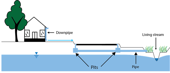
Configuration 3 drainage systems involve pit-and-pipe systems (or overland flow) as their primary mechanism for stormwater runoff. They are generally associated with heavy clay soils outside the sandy areas of the Swan Coastal Plain, but are also associated with road reserves on parts of the Swan Coastal Plain where pit-and-pipe systems are used to convey stormwater. Two conceptualisations of Configuration 3 drainage configurations are shown in Figure B-4.
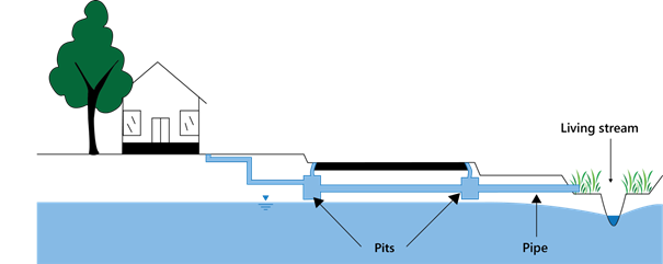
(A)
(B)
Figure B-4: Two configurations for the conceptual model for Configuration 3: Piped drainage which includes A) piped drainage with lot connection, and B) overland flow for urban allotments that drain to a pit-and-pipe system for roads
Subregion configuration in the UNDO tool
Residential lots (or commercial/industrial lots), public open space and road reserves can generally be lumped within the same subregion using a Configuration 3 drainage (provided the soil type and fill properties are relatively consistent throughout the development area), as both land categories use a piped system for drainage. In some instances roof runoff and impervious runoff from urban lots will not be piped, but will drain to the road via overland flow (e.g. down the driveway) to the road where it enters a pit-and-pipe stormwater system. In this case the drainage typology for the urban allotments is assumed to be piped drainage for the purposes of the UNDO tool (Figure B-4b).
General application of drainage type
Configuration 3 drainage configurations were very common on the Swan Coastal Plain in traditional urban developments (pre-2000), where a piped drainage network was combined with deep open channel drains that would lower groundwater levels, so subsoil drains were not needed. However, in the past decade water sensitive urban design principles have been adopted by most land developers, and this drainage typology is far less common on the Swan Coastal Plain. Outside the sandy coastal plain Configuration 3 drainage is relatively common in urban developments with heavy soils; for example, on the Darling Scarp, the Perth Hills, or the Cape-to-Cape region around Margaret River.
Configuration 4: Open channel drains
Configuration 4 drainage is generally only used in the UNDO tool if the development is associated with rural living landuse (for roads, allotments and public open space). Open channel drains can also be associated with public open space in high water table developments.
The conceptual model for Configuration 4 drainage is shown in Figure B5. On road reserves, open channel drainage is usually located on the left and right verges. Runoff from rural residential allotments will either infiltrate to the groundwater or flow overland to an open channel network. The channels generally drain both surface water and groundwater. If Configuration 4 drainage is selected in UNDO, by definition the development area cannot have any pit-and-pipe network, and subsoil drainage systems are not used to control groundwater levels.

Figure B-5: Conceptual model for the drainage Type 1: Open channel drains
Subregion configuration in the UNDO tool
Configuration 4 drainage is generally associated with the rural living land-use category. In the UNDO tool, this land-use category is one of the only examples where it is possible for an entire development to be represented by a single subregion (provided the soil type is relatively consistent throughout the development area). This is because the residential, road reserve and public open space areas can all be represented by open channel drainage. In instances where part of a development comprises rural living allotments and another part has higher density urban allotments, the development will need to be split into subregions.
General application of drainage type
Configuration 4 drainage (open channel drains in rural living areas) is generally used where it is not feasible to develop a piped stormwater network and where there is sufficient space for open channel drainage systems negating the need for piped or subsoil systems (other than crossings). Configuration 4 drainage can be used on the sandy sections of the Swan Coastal Plain or on heavier soils. In the sandy sections of the Swan Coastal Plain, inundation is generally managed by agricultural drainage and groundwater is generally close to ground level with fill used to provide separation between house foundations and groundwater. In heavier soils with deeper groundwater (for example, associated with developments on the Darling Scarp), there usually much more relief, and the channels are generally more natural waterways.
Configuration 5: Subsoil drainage (urban residential and road reserve)
Configuration 5 drainage systems use subsoil drains (slotted piping) to control groundwater levels and as such provide a drainage outlet for water infiltrating from urban lots and road reserves. This type of drainage is associated with high groundwater areas on the Swan Coastal Plain. Configuration 5 drainage systems do not use pit-and-pipe systems for stormwater conveyance, and all runoff from small rainfall events infiltrates ‘at-source’. Runoff from roads infiltrates at-source via roadside swales, biofilters or infiltration cells/trenches. A conceptual model is shown in Figure B-6.
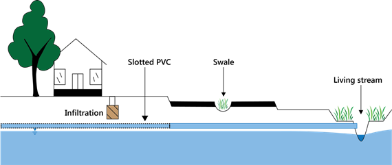
Figure B-6: Conceptual model for the drainage Configuration 5: Subsoil drainage (road reserve and urban residential)
Subregion configuration in the UNDO tool
In the UNDO tool, the urban residential and road reserve land categories can generally be lumped into the same subregion with Configuration 5 drainage (provided the soil type and fill properties are relatively consistent throughout the development area). However, public open space (particularly public open space used for drainage management) rarely uses subsoil drains to control the groundwater level, and in these instances the public open space will require a separate subregion and drainage type (generally open channel drains or infiltration, depending on whether a living stream or channel drain is present).
General application of drainage type
Configuration 5 drainage is used in developments on the Swan Coastal Plain with shallow groundwater. This drainage type is associated with new developments in the southern Swan Coastal Plain, between Perth and Busselton, inland from the coastal dunes and west of the Darling Scarp. This drainage is generally associated with Bassendean or Guildford soils (where sand fill is used to create a separation between lot levels and the groundwater table). It is recommended that water in subsoil drains is treated before it is discharged to living streams or to the catchment outlet.
Configuration 6: Subsoil drainage (urban residential) and piped drainage (road reserve)
Configuration 6 drainage systems use subsoil drains (slotted piping) to control groundwater levels beneath urban allotments, and pit-and-pipe stormwater systems for road runoff. This drainage type is associated with sandy soils and high groundwater levels, usually on the southern Swan Coastal Plain inland from the coastal strip. A conceptual model is shown in Figure B-7.
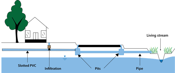
Figure B-7: Conceptual model for the drainage Configuration 6: Subsoil drainage (urban residential) and piped drainage (road reserve)
Subregion configuration in the UNDO tool
Configuration 6 drainage requires that the UNDO project puts the road reserve and the urban residential land-use categories into separate subregions. In addition, the public open space land category will usually require splitting to a separate subregion, as public open space rarely uses subsoil drains to control the groundwater level. Urban residential land use is categorised with subsoil drainage, the road reserve land category with piped drainage, and the public open space with infiltration or open channel drains, depending on whether a living stream or drainage channel is present.
General application of drainage type
Configuration 6 drainage is very common in new development areas on the Swan Coastal Plain, where groundwater is shallow and subsoil drains are required to control the groundwater level. These drainage systems are associated with new developments in the southern Swan Coastal Plain, between Perth and Busselton inland of the coastal dunes but west of the Darling Scarp. Configuration 6 drainage is generally associated with Bassendean or Guildford soils (where sand fill is used to create a separation between lot levels and the groundwater table). The subsoil system used to control groundwater levels under urban lots and road reserves usually discharges to the pit-and-pipe network associated with roads, then generally routed to biofilters, swales or living streams.
Configuration 7: Subsoil drainage – partial lot connection (urban residential) and piped drainage (road reserve)
Configuration 7 drainage systems involve a hybrid piped/infiltration system for impervious runoff from urban developments connected to a pit-and-pipe roadside stormwater system. These systems are also referred to as ‘partial lot connection’, meaning that the impervious runoff from urban developments is routed directly to small infiltration cells/detention tanks which can overflow to the roadside stormwater system via overflow pipes. These systems also use subsoil drains (slotted piping) to control groundwater levels underneath urban lots. The conceptual model is shown in Figure B-8.
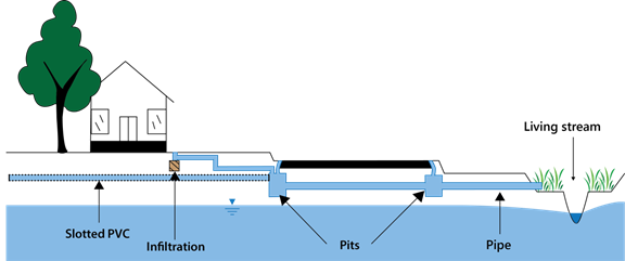
Figure B-8: Conceptual model for the drainage Configuration 7: Subsoil drainage – partial lot connection (urban residential) and piped drainage (road reserve)
Subregion configuration in the UNDO tool
Configuration 7 drainage requires that the UNDO project divides the road reserve and the urban residential (or commercial/industrial) land-use categories into separate subregions. In addition, the public open space land category will generally require a different subregion, as public open space rarely uses subsoil drains to control the groundwater level. The urban residential land category will be categorised with subsoil drainage – partial lot connection, the road reserve land category with piped drainage, and the public open space with infiltration or open channel drains, depending on whether a living stream or drainage channel is present.
General application of drainage type
Configuration 7 drainage systems are occasionally used in new development areas on the Swan Coastal Plain where groundwater is shallow and subsoil drains are required to control the groundwater level. This is most prevalent in recent developments in the southern Swan Coastal Plain, between Perth and Busselton, inland of the coastal dunes but west of the Darling Scarp. The subsoil system used to control groundwater levels will drain to the pit-and-pipe network associated with roads, and the infiltration systems associated with urban allotments will overflow to a piped system that will drain to the roadside stormwater system. The pit-and-pipe drainage network is generally routed to biofilters, swales or living streams.
Configuration 8: Subsoil drainage – full lot connection (urban residential) and piped drainage (road reserve)
Configuration 8 drainage systems involve a piped system for impervious runoff from urban lots which connect to a pit-and-pipe roadside stormwater system. These systems are also referred to as ‘full lot connection’, meaning that the impervious runoff from urban developments is routed directly to the roadside stormwater system via overflow pipes. These systems also use subsoil drains (slotted piping) to control groundwater levels. The conceptual model is shown in Figure B-9.
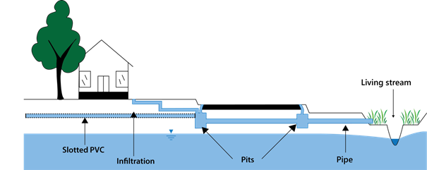
Figure B-9: Conceptual model for the drainage Configuration 8: Subsoil drainage – full lot connection (urban residential) and piped drainage (road reserve)
Subregion configuration in the UNDO tool
Configuration 8 drainage configuration requires that the UNDO project divides the road reserve and the urban residential land-use categories into separate subregions. In addition, the public open space land category will generally require a different subregion, as public open space rarely uses subsoil drains to control the groundwater level. The urban residential land category will be categorised with subsoil drainage – full lot connection, the road reserve land category with piped drainage, and the public open space with infiltration or open channel drains, depending on whether a living stream or drainage channel is present.
Configuration 8 drainage systems are relatively common on the Swan Coastal Plain in high groundwater areas, and are generally associated with small lots (generally < 300 m2), where the local government deems that there is insufficient space to install appropriate infiltration cells or the site is geotechnically constrained and infiltration cells are unsuitable. Configuration 8 drainage is associated with new developments on the southern Swan Coastal Plain between Perth and Busselton, inland of the coastal dunes but west of the Darling Scarp. The Department of Water recommends that this type of drainage is only used for dense lot configurations in highly constrained areas, and sufficient justification to this effect will be required if such a design is proposed. If stormwater cannot be managed on lot, then management should be undertaken as near to the source as possible, for example in the road verge or median.