Approach to applying the UNDO tool
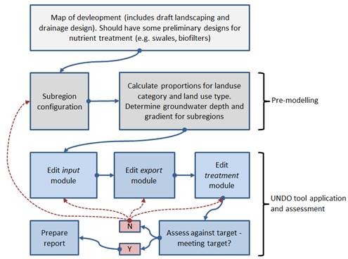
A flow diagram showing the general approach to applying the UNDO tool for nutrient management in urban developments is shown in Figure 2-2.
The application of the tool should be undertaken in-line with the development’s drainage and landscape design as part of the local water management strategy. A pre-requisite for applying the UNDO tool is a map of the development with some preliminary landscape and drainage designs. It is important that these designs are preliminary so adjustments can be made to ensure nutrient targets are met with minimal disturbance to the planning process of the development.
Pre-modelling
Pre-modelling refers to the configuration and calculations required by the user so that data is ready to enter into the UNDO tool. There are two major stages in this: subregion configuration and data configuration. Subregion configuration is where the user decides how many subregions to divide the development into. More information on this is shown in Appendix A: a guide to configuring subregions in the UNDO tool.

Figure 2-2 : Flow diagram outlining the approach for using the UNDO tool
The data configuration can only be undertaken when the user has established an initial subregion configuration. It is common to use GIS software or spreadsheets to help in the data configuration which involves the following steps for each subregion:
-
Calculate the proportion of each land-use category within the subregion: Use the basic development design (see Section 4.3 for more information).
-
Calculate the proportion of each land-use type making up each land-use category: Use the draft landscaping design (see Section 4.4 for more information).
-
Calculate the average depth to (average) groundwater level: Use groundwater bore analysis, also required for a local water management strategy (see Section 5.1 for more information).
-
Calculate the groundwater gradient: Use groundwater bore analysis, also required for a local water management strategy (see Section 5.1 for more information).
-
Work out the soil type: There is a map interface in the UNDO tool to help with this (see Section 5.1 for more information).
-
Calculate the average fill depth if fill is used and estimate the approximate PRI of this fill if it is not standard Bassendean (white) or Spearwood (yellow) sands (this will need to be confirmed by laboratory analysis and submitted with the report – see Section 7).
-
Calculate the length of swales and living streams, if present, and the approximate area of biofilters, wetlands and dry ephemeral detention areas, if present.
The configured data is ready to be entered directly into the UNDO tool.
UNDO tool application and assessment
The UNDO tool is used to evaluate the nutrient design of the development, and is ready to use once the pre-modelling is complete. The data are entered into the input, export and treatment modules, respectively. When the treatment module is complete the user is provided with an export load of nitrogen and phosphorus.
This can be assessed against any development targets (which should have been identified in the district planning stage). If the targets are met, the current development nutrient management design is satisfactory and a report can be printed and sent to the relevant decision-making authorities (with the appropriate data attached. See Report section for the data that must be submitted with an UNDO report).
If the targets are not met, the development design may have to be altered and the user has the opportunity to edit the input, export or treatment modules in the UNDO tool, or alternatively to reconfigure the subregions (in which case pre-modelling will have to be re-done for the re-configured subregions). This process is repeated until nutrient targets are met.