Export
The second page of the UNDO tool is the export page, which calculates the amount of nutrient exported from the catchment at an ‘edge-of-lot’ scale. This part of the tool calculates the quantity of nutrient exported from the land parcel before it is routed through a drainage system and/or a series of treatment devices. The configuration of the export page is shown in Figure 5-1.
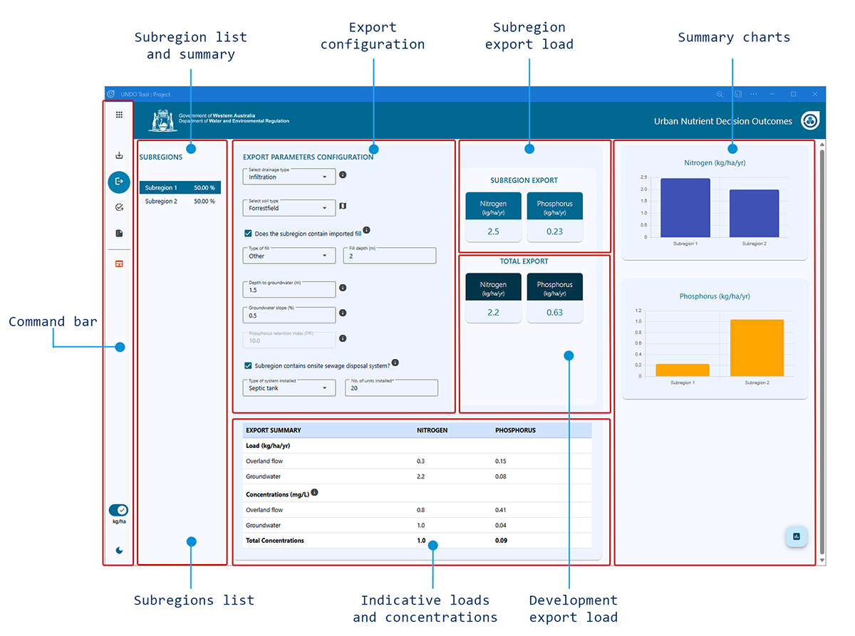
Figure 5-1: Configuration of the UNDO tool - Export page
Export configuration
The export configuration panel is shown in Figure 5-2. This is the only section of the export page that the user is required to complete, and provides subregion details of drainage type, soil type, fill depth, depth to groundwater, phosphorus retention index (PRI) of any imported fill and details of onsite sewage disposal systems if they are present. Each of the options displayed on the panel is detailed below.
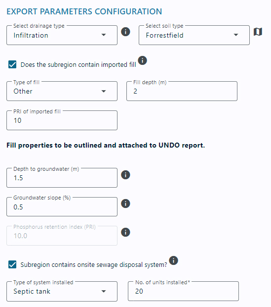
Figure 5-2: The export configuration panel of the Export page
Select drainage type
Six drainage types can be selected in the UNDO tool. Conceptual diagrams for each of these drainage types for urban lots, public open space (POS) and road reserves is shown in Figure 5.3. The six drainage types are outlined below:
-
Infiltration : Infiltration is common on the sandy Swan Coastal Plain, where there is a large depth to groundwater (generally greater than 3 metres) and subsoil drains or open channel drains are not required to control groundwater levels. Infiltration drainage systems do not contain any stormwater pipes, and all rainfall (up to the first 15mm of a rainfall event), is infiltrated on site. Very little runoff is exported from infiltration drainage systems, as most of stormwater is infiltrated deep into the soil profile, where it is exported via groundwater.
-
Open channel drains : Open channel drains are common on the Sandy Swan Coastal Plain where groundwater levels are controlled by open channel drains, but subsoil drains are not used. This is common for rural living developments, where the house pad is raised, but other parts of the urban allotment may become waterlogged in Winter and Spring months. It is also a common drainage type for public open space in developments that use living streams as drainage mechanisms.
-
Piped/overland drainage : Piped or overland drainage is common in heavier soils. It is important to note that overland drainage in this typology means that the water will be conveyed overland in small rainfall events (up to the first 15mm of a rainfall event). It is recognised that all drainage systems will have some overland drainage in rainfall events larger than the first 15mm of a rainfall event. Overland drainage is common on heavier soils in the Darling Scarp, east of the Swan Coastal Plain, or on the Blackwood Plateau, south of the Swan Coastal Plain. Piped drainage is also common in road reserves on the sandy sections of the Swan Coastal Plain, where pit-and-pipe systems are used to convey runoff (this commonly occurs in conjunction with infiltration and/or subsoil drainage systems which are used to drain the urban allotments, and developments need to be divided into separate subregions to account for the different drainage types, see Appendix B for details).
-
Subsoil drainage : Subsoil drainage occurs on the Swan Coastal Plain where small rainfall events are infiltrated on site, but the groundwater level is controlled using subsoil drains. This drainage typology is associated with high groundwater tables. On clay or duplex soils (such as Guildford Clays and Pinjarra soils type), subsoil drainage is common, and sand fill is imported to separate the groundwater table from the building footings. Subsoil drainage is generally associated with urban residential lots only, and is less common in road reserves and public open space. However, subsoil drainage is increasingly being used to control groundwater levels in active turf (sporting grounds, ovals and playing fields).
-
Subsoil – partial lot connection : Subsoil drainage with partial lot connection occurs on urban allotments where not all of the first 15mm is infiltrated at site (usually due to constraints on block size and location of infiltration systems). Therefore more water will be exported through runoff, and less water will be infiltrated to the groundwater. UNDO assumes that urban lots with partial lot connection will infiltrate the first 7.5mm of rainfall. Subsoil drainage with partial lot connection is not associated with public open space or road reserves.
-
Subsoil – full lot connection Subsoil drainage with full lot connection occurs on urban allotments where no water is infiltrated at site (usually due to constraints on block size and location of infiltration systems). Therefore significantly more water will be exported through runoff, and less water will be infiltrated to the groundwater. Subsoil drains are used to control groundwater levels. Subsoil drainage with full lot connection is not associated with public open space or road reserves.
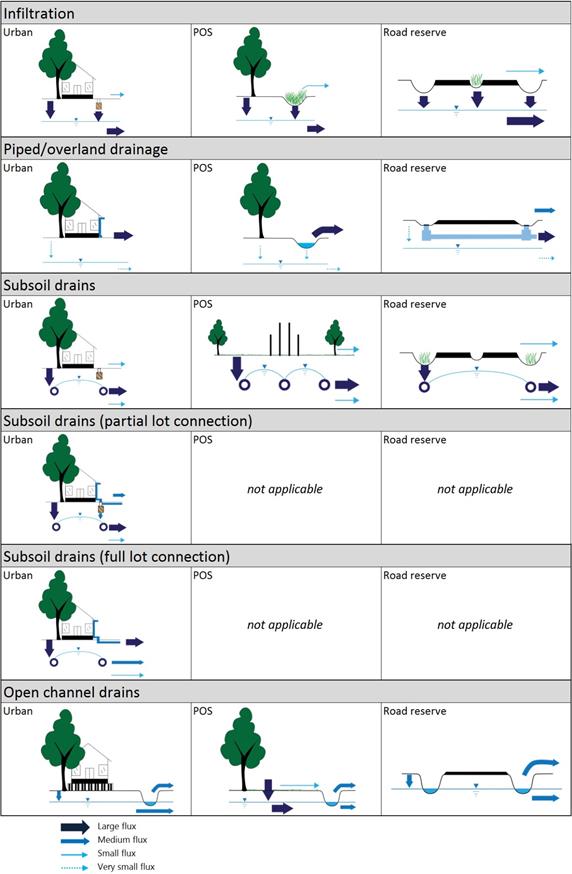
Figure 5-3: Conceptual diagram of each drainage type in the UNDO tool
Each subregion can only be assigned one drainage type. A typical urban development on the Swan Coastal Plain is a mixture of drainage types, and users are required to divide the development into various subregions to account for the different drainage types. A guide to subregion configuration based on drainage typology for the UNDO tool is provided in Appendix B.
Select soil type
The soil type is particularly important in the nutrient export processes on the Swan Coastal Plain of Western Australia, as a large proportion of the rainfall can infiltrate into the ground, where the water interacts with the soil matrix and groundwater and is discharged via subsoil drains or through groundwater flow to receiving water bodies. Soils are categorised according to their phosphorus retention index (PRI), porosity and vertical hydraulic conductivity. PRI is a measure of the soil’s ability to retain phosphorus: soils with low iron content (such as Bassendean Sands which are common on the Swan Coastal Plain) have low to very low PRI, and soluble phosphorus concentrations leaching to groundwater systems and subsoil drains are likely to be high. The PRI assigned to each soil type will be displayed in the non-editablePhosphorus retention index (PRI) text box. Effective porosity and vertical hydraulic conductivity are required to calculate travel times of flow through both the unsaturated and saturated soil media. Travel times are related to the extent of potential nutrient processing. More information on PRI, travel times, nutrient processing, and soil parameters is shown in the UNDO tool technical manual, Section 5. The UNDO tool includes a map icon ( ) located next to the drop-down menu for soil type. This map opens an interactive map which allows users to pin-point the soil type of their development. An example of the interactive map viewer is shown in Figure 5-4.
Does the subregion contain imported fill?
Imported fill is commonly used in WA soils to provide the ‘Class A’ foundations required to support double-brick housing and to provide adequate clearance from groundwater. It is increasingly being used to provide a matrix for phosphorus absorption. Various soil amendments are available to raise the phosphorus binding capacity of the soil. This may be important in developments on Bassendean Sands, where the soil’s natural phosphorus binding capacity is very low. If the check-box is ticked, two or three text boxes will be displayed below the check box (Figure 5-5).

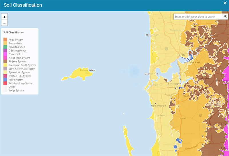
Figure 5-4: The map viewer used to help select soil type
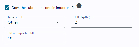
Figure 5-5: Sand fill details in the UNDO tool’s export page
The first text box outlines the type of fill. At the local water management strategy stage of the project, it is unlikely that the developer will know exactly where the fill will be sourced from but this text box commits the developer to getting the fill from a certain source. There are three options:
- White Sands (Bassendean): These sands have poor phosphorus binding capabilities but are often the easiest fill to source locally in developments on Bassendean Sands.
- Yellow Sands (Spearwood):Spearwood sands have a much greater capacity to retain phosphorus onsite than Bassendean Sands (but not particularly good compared to iron-rich soils).
- Other: This includes any other specified soils for fill not covered by the other options, and includes amended soils. If this option is selected, the user must also provide the PRI of this soil type, and attach a description of the proposed soils to the UNDO tool report.
Depth to groundwater
The depth to groundwater will characterise the distance the infiltrated water will travel through the soil profile, which will affect the amount of phosphorus adsorption onto the soil matrix. Groundwater levels are likely to fluctuate from year to year, and an average depth to groundwater is required for the UNDO tool.
The average depth to groundwater is expected to vary across the subregion. Ideally, subregions should have a relatively constant depth to groundwater but it is impractical to split a development into many subregions based on subtle/minor depth variations. So, subregion design is made independently of the depth to groundwater calculation (see Appendix A for a guide for subregion configuration), and the spatially average depth to groundwater is required based on each of the subregions and calculated in the pre-modelling phase (Section 2).
If a subsoil drainage system is used to control groundwater, the depth to groundwater will be equal to the depth to the subsoil drainage system (which will generally correspond to the depth of fill).
Groundwater gradient
An average groundwater gradient for each subregion is required for the UNDO tool. Users can calculate the gradient for each subregion in the pre-modelling phase using information from drilling and monitoring programs. Alternatively, groundwater gradients can be calculated using contours maps taken from any existing drainage and water management plans (if these are available for the development area).
Maps of existing groundwater levels and any proposed controlled groundwater levels are a requirement of a local water management strategy under the Better urban water management framework (WAPC 2008), so the information on groundwater gradient and depth should be readily available for the UNDO tool at the appropriate stage of development.
Subregion contains onsite sewage disposal system
Onsite sewage disposal systems can be a significant source of nutrients in urban or rural living areas. Although it is a general requirement that future residential developments are connected to mains sewerage, exceptions are allowed under certain circumstances, and users should refer to the State sewerage policy (Department of Health 2011) to ensure that any use of onsite sewage disposal systems in a development is aligned with this policy. Developments in rural areas and urban fringe locations are examples where onsite sewage disposal systems may be installed due to absence of sewerage infrastructure and provision under the State sewerage policy. If onsite sewage disposal systems are used in the UNDO tool, the ‘subregion contains onsite sewage disposal system’ tick-box must be selected, and two text boxes will appear (Figure 5-5). The top text box is a drop-down list of the type of septic installed – two types are available in UNDO: Septic tanks and alternative treatment units (ATUs).

Figure 5-6: Onsite sewage disposal system details in the UNDO tool
Septic tank systems generally consist of one or two watertight cylindrical tanks and one or two sets of drainage receptacles with holes in their sides and no base, e.g. leach drains or soakwells. When wastewater passes through the septic tanks, heavier solids sink to the bottom and undergo bacterial digestion. This reduces the mass of solids and changes its composition to sludge which builds up in the bottom of the tank. Materials such as grease and oil float to the surface in the tanks to form a crust over the liquid. The remaining liquid, called effluent, flows from the tanks into the drainage receptacles to soak into the surrounding soil. Since 1989, most household septic tank systems have been installed with either two leach drains or two sets of soakwells. These systems are called alternating systems as they have a diverter box that can change the flow of effluent allowing one half of the soakwells or one of the leach drains to be shut off at any time.
Alternative treatment units (ATUs) are local wastewater systems which can be used instead of septic tanks. In some locations they are used to treat effluent from more than one house. ATUs have advanced physical, biological and/or chemical treatment systems that can reduce coliform, nitrogen, phosphorus and suspended solid effluent concentrations. Aerobic treatment units treat wastewater under aerobic conditions and can have a series of additional treatment components before discharging the treated wastewater.
For an ATU to be accredited for use in Western Australia, the system must have its performance independently verified and reported to the Western Australian Department of Health. These performance tests measure the reduction rates of total coliforms, suspended solids, nitrate, ammonium, total nitrogen, soluble phosphorus, total phosphorus and biological oxygen demand. ATUs have regular service requirements (usually quarterly) and maintenance must be through an authorised person or their staff/contractors. Users of the UNDO tool should refer to the Code of practice for the design, manufacture, installation and operation of Aerobic Treatment Units (Department of Health 2001) if the proposed development may use ATUs and users require more information. Further information is available online at http://www.public.health.wa.gov.au/3/663/2/aerobic_treatment_units.pm.
More information on onsite sewage disposal systems can be found in the UNDO tool technical manual, Appendix E.
Indicative average nutrient concentrations
The UNDO tool calculates an indicative nutrient concentration as part of the nutrient export algorithms. Details of the calculations are shown in the Section 4 UNDO tool technical manual. The calculations assume an annual rainfall of 750 mm, and do not take into account the inter-annual variability of flow or nutrient fluxes. The values are a guide only to show users that the UNDO tool is predicting realistic outputs. It should also be noted that the concentration is not directly proportional to the export load, as drainage systems that export more flow (e.g. piped drainage systems) can export an equivalent catchment load for much lower nutrient concentrations.