Input
When a user creates an UNDO project (using the project setup panel) or if a user loads an existing project, the UNDO tool interface will open and display the input page. The input page is the first page a user will populate, and it calculates the quantity of nitrogen and phosphorus applied to the development area. The configuration of the input page and a description of all of its components are shown in Figure 4-1. The components of the input page are described below in the following sections.
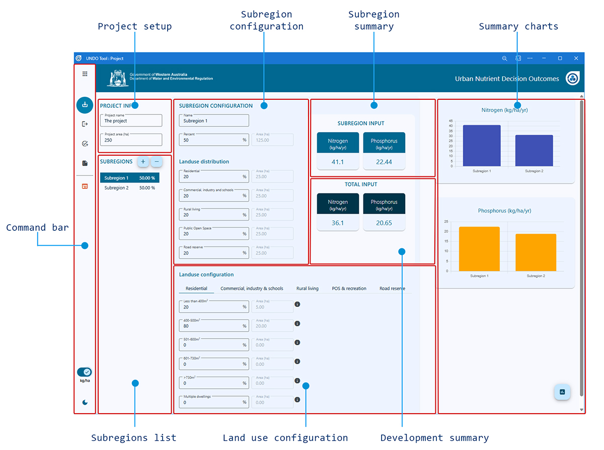
Figure 4-1: Configuration of the UNDO tool input page
Project setup
This panel is pre-configured from the project setup which is displayed when a user creates a project. The project setup can be adjusted any time during the project development and includes the name of the UNDO project (this can be the name of the development or a version of the development being tested with a particular instance of the UNDO tool) and the total area of the development (in hectares). It also includes the reporting units for the project, which can be in absolute load (kg/yr) or relative load (kg/ha/yr). The default is for absolute load.
Subregions list
This panel shows each of the subregions that make up the development (see Appendix A for more information on subregions, including guidance for users to develop their UNDO project into a series of subregions), and a button to create extra subregions. The list of subregions displays the name given to the subregion (which can be edited in the ‘subregion configuration’ panel) and the percentage of the development area occupied by the subregion displayed in small blue circle icon. The subregion list is ‘clickable’, so users can click on a particular subregion and it will be available to edit in the subregion configuration and land-use configuration panels.
Subregions can be deleted or added to the project using the '+' or '-' buttons at the top of the panel.
Subregion configuration
The subregion configuration panel allows the user to adjust the size and the types of land use, the name and percentage of the total development area. The subregion area (in hectares) is shown but is not editable. There are five land-use categories to choose from:
- Residential
- Commercial, industrial and schools
- Rural living
- Public open space & recreation
- Road reserve
A detailed description of each land use is provided in Section 4.4. Rural land-use types are not available in the UNDO tool, as the tool is developed specifically for urban developments. Guidance for the appropriate configuration is provided in Appendix A: A guide to configuring subregions in the UNDO tool.
Land use configuration
The land-use configuration panel allows users to add further detail to the land-use definitions within the five land categories. This process assigns a nutrient input rate to a particular land use. The five categories are further broken down to land-use types which are described below.
Residential
By definition, residential land uses include all buildings with permanent accommodation for people. This category mostly comprises single dwellings, but can include the residential component of mixed-use dwellings, aged persons accommodation, group dwellings and communal properties (which are entered under the category ‘multiple-dwellings’). The UNDO tool further divides these lots into four categories (< 400 m2, 400–600 m2, 601–730 m2, and 730–2000 m2, or strata (multiple-dwelling developments). The setup of the ‘Residential’ table of the land-use configuration panel is shown in Figure 4-2.
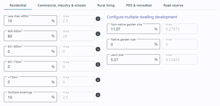
Figure 4-2: Residential tab from the UNDO tool’s land-use configuration panel
The lot size categories are based on analysis that was part of the Department of Water’s urban nutrient survey (Kelsey et al. 2010), which indicated that dwellings of different sizes apply different fertiliser rates (for more information see the UNDO Technical Manual, Appendix B). The average garden size and lawn area for each of these lot size categories were also derived from this document, and are fixed (i.e. the user cannot adjust these values). The average garden size, lawn size, and nutrient input rates for each of the residential categories is shown in Table 4-1.
Table 4-1: Average lawn size, garden size and nutrient input rate for residential land-use categories
| Land-use category | Average garden size (m2) | Average lawn size (m2) | N Input (kg/ha/yr) | P Input (kg/ha/yr) |
|---|---|---|---|---|
| Residential <400m2 | 33 | 16 | 23.4 | 6.9 |
| Residential 400-500m2 | 55 | 52 | 67.9 | 17.1 |
| Residential 501-600m2 | 65 | 91 | 98.6 | 26.4 |
| Residential 601-730m2 | 78 | 115 | 101.0 | 25.6 |
| Residential 730-2000m2 | 123 | 189 | 74.2 | 18.0 |
There are some instances where residential lots will be greater than 2000 m2 (i.e. when the R-code is R2–R5 lot sizes will be 2000–5000 m2). Although these lots are zoned 'residential', for the purpose of the UNDO tool they are to be placed in the ‘Rural living’ land category.
The user is required to enter the percentage of residential area within that particular lot size-range. Aged persons accommodation, group dwellings or communal properties, if entered, are placed in the ‘multiple-dwellings’ category. The UNDO tool has an option for the user to configure these developments so they can be landscaped to provide a limited size of non-native and native garden area. If this option is chosen, the user must provide evidence that this configuration will be upheld during the development stage of the project – otherwise default values should be used. The default for this category is for the same average percentage of garden and lawn size as for residential lots below 400 m2 (Table 4-1).
Commercial, industry and schools
This category includes commercial buildings, offices, schools, public buildings, heavy and light industrial areas. The design of the ‘Commercial, industry and schools’ tab for the UNDO tool is shown in Figure 4-3.
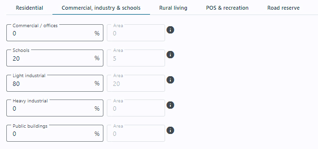
Figure 4-3: Commercial, industry and schools tab from the UNDO tool’s land-use configuration panel
The user assigns a proportion of the total ‘Commercial, industry and schools’ area to one of five subcategories, each of which has assigned nutrient application rates:
-
Commercial/offices: refers to commercial and service businesses such as shops, banks, post offices, medical centres, childcare centres, service stations, car showrooms and sales yards, hotels, taverns, restaurants. The shops can be small individual premises along a street or large shopping centres. The offices may be surrounded by parkland or not. The nutrient input rates were calculated by analysing aerial photography of commercial/office areas to determine relative areas of lawn, garden and impervious surface, so that lot input rates could be estimated from fertilisation rates to garden beds and lawns (N input = 26.4 kg/ha/yr, P input = 6.4 kg/ha/yr).
-
Schools: refers to kindergartens, primary schools, high schools and universities. Although small schools such as parent-run kindergartens may have very different garden and ground maintenance compared with large private schools they have been lumped together. Note that playing fields for large schools will generally be included in the active turf classification. The nutrient input rates were decided by analysing aerial photography of schools to assign relative areas of passive and active turf, garden and impervious surface, so that lot input rates could be estimated from fertilisation rates to turf and garden beds (N input = 97.7 kg/ha/yr, P input = 19.1 kg/ha/yr).
-
Light industrial: refers to small manufacturing and service facilities such as food processing, car servicing, joinery and other trades, and storage and distribution sites. The nutrient input rates were selected by analysing aerial photography of light industrial areas to assign relative areas of lawn, garden and impervious surface, so that lot input rates could be estimated from fertilisation rates to garden beds and lawn areas (N input = 14.3 kg/ha/yr, P input = 2.9 kg/ha/yr).
-
Heavy industry: refers to areas such as the Kwinana Industrial Area and the Australian Marine Complex (Henderson). These areas host heavy industries such as alumina smelters, power-production plants, mineral and oil refineries, steel works, fertiliser works and ship-building industries. These land uses will generally not be part of urban developments modelled with the UNDO tool. Nutrient inputs are generally limited to small areas of gardens that beautify entrances to offices and other sites. Nutrient input estimations for heavy industries are taken to be the same as for light industries (N input = 14.3 kg/ha/yr, P input = 2.9 kg/ha/yr).
-
Public buildings: refers to council and shire offices, libraries, hospitals, fire stations, churches and community centres, art galleries and museums and function centres. Public buildings generally have only small areas of garden. Nutrient input rates for public buildings were assumed to be the same as for commercial/offices (N input = 26.4 kg/ha/yr, P input = 6.4 kg/ha/yr).
Rural living
The rural living category is used loosely in the planning industry, but for the purposes of the UNDO tool, this includes residential lots larger than 2000 m2 and smaller than 2 ha. They comprise low-density residential subdivisions and rural allotments created primarily for residential purposes, excluding dwellings associated with bona-fide agricultural holdings. In planning terms, rural living can include (but are not limited to) the following zones:
-
Rural-residential: Land is used for residential purposes in a rural setting which provides for alternative residential lifestyle and which seeks to preserve the amenity of such areas and control land-use impacts.
-
Rural smallholdings: Land is used for minor rural pursuits, hobby farm, conservation lots and alternative residential life style purposes where part-time income from cottage industries, home occupation and use of the land for agriculture may be derived.
-
Special residential: Allows for lots of a size that will offer a style of spacious living at densities lower than those characteristic of traditional single residential developments: between 2000 m2 and one hectare. Generally in areas that have already been zoned ‘urban’.
-
Urban residential (R2–R5): Where the R-code is R2–R5 lot sizes will be 2000–5000 m2, and although these have a residential zoning, for the purpose of UNDO they are to be placed in the ‘Rural living’ category.
Rural living dwellings are likely to have onsite sewage disposal systems. They may have some rural activities on them (e.g. horses, small orchards, or some livestock). It is common for rural living precincts to have restrictions on the title or within the planning scheme, which excludes various activities from being allowed on the lot. The design of the ‘Rural living’ tab for the UNDO tool is shown in Figure 4-4.
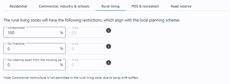
Figure 4-4: Rural living tab from the UNDO tool’s land-use configuration panel
Three levels of restrictions can be placed on rural living lots within the UNDO tool:
-
Unrestricted: Unrestricted rural living lots are permitted by local government authorities to rear livestock, which may include horses, sheep, cows, goats, alpacas or other animals. They may be kept as pets or as a small commercial enterprise. Nutrient inputs are from imported feed, fertilisation and nitrogen fixation. The Department of Agriculture and Food WA have done extensive farm-gate nutrient balance studies in the south-west of WA. Unrestricted rural living lots are assumed to have the same nutrient input rates as horses (N input = 79.5 /ha/yr. P input = 13.2 kg/ha/yr).
-
No livestock: This land-use classification refers to rural developments that have livestock and horse-rearing restrictions. Such developments are assumed to be permitted to undertake other forms of non-intensive agriculture, such as orchards, viticulture and small-scale horticulture (N input = 6.0 /ha/yr, P input = 4.1 kg/ha/yr).
-
No clearing apart from the housing pad:This land-use classification refers to highly restricted developments within native forest. Clearing is only permitted for the house footprint and fire breaks. No fertilisation is assumed apart from the nutrient inputs of native vegetation and from atmospheric deposition (N input = 9.23 /ha/yr, P input = 0.15 kg/ha/yr).
Note: nutrients from onsite sewage disposal are accounted for in the nutrient export section.
Any restrictions placed on rural living developments in the UNDO tool must be clearly marked on the development plan, and the process to enact the restrictions must be described in the corresponding local or urban water management strategy. This can include modifications to the planning scheme, or restrictive covenants on titles.
Commercial annual horticulture has an extremely high nutrient input rate (much higher than horses) but it is assumed that commercial horticulture is not allowable in urban developments, due to recent Department of Health policy on spray drift buffers (Department of Health 2012). Annual horticulture is not considered in the ‘Rural living’ category.
Public open space & recreation
This category includes land set aside for unrestricted recreational activities within an urban development. According to development control policy 2.3 (WAPC 2002), a minimum of 10 per cent of the developable area must be set aside for public open space in residential developments within Western Australia. Land uses include gardens, ovals, bicycle paths, remnant native vegetation, public golf courses, stormwater management systems and water bodies which provide a recreational amenity. For the purposes of the UNDO tool, public open space may include some restricted land uses, including golf courses, bowling greens, and sports stadiums. The design of the ‘Public open space’ tab of the land-use configuration panel is shown in Figure 4-5. Landuses that have not fertiliser applied directly are assigned an atmospheric deposition rate of 5.23 kg/ha/yr N and 0.15 kg/ha/yr P. A literature review and results of measured data on atmospheric deposition can be found in the “atmospheric deposition” fact sheet.
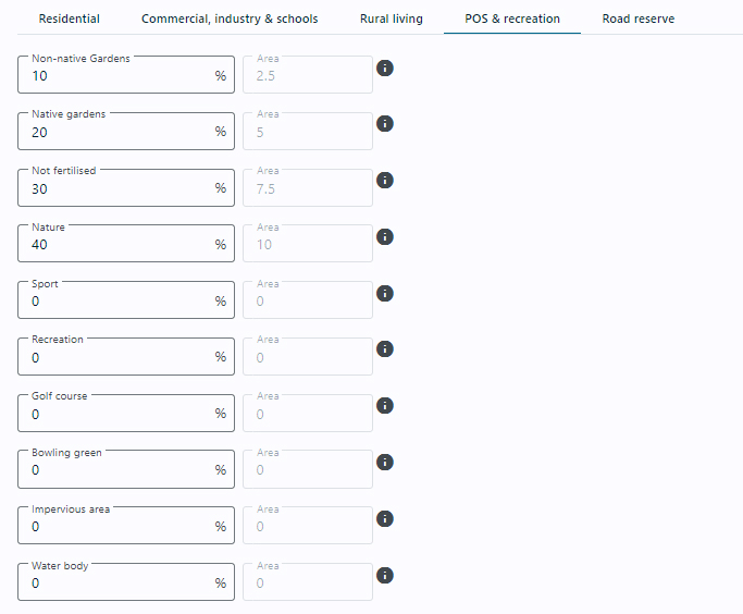
Figure 4-5: Public open space & recreation tab from the UNDO tool’s land-use configuration panel
The ‘Public open space & recreation’ land-use category has 10 subcategories:
-
Non-native gardens: Areas of public open space planted with species that are not Australian natives. These rates have been derived from a survey of the fertilisation practices of 20 local government authorities in the Perth metropolitan area by the South East Regional Centre of Urban Landcare (N input = 77 kg/ha/yr, P input = 24 kg/ha/yr).
-
Native gardens: Areas of public open space planted with native species. Inputs are from fertilisation and fixation. These inputs rates are those estimated for residential native gardens. The rates for native gardens in POS maintained by local and state government authorities may be different and more information is being sought to update these rates (N input = 28.0 kg/ha/yr, P input = 0.9 kg/ha/yr).
-
Not-fertilised: Areas of POS that are not maintained or deliberately not fertilised. POS that is non-maintained remnant native bush is classified as Remnant Bush. They are assigned atmospheric fertilisation rates only (N input = 5.23 kg/ha/yr, P input = 0.15 kg/ha/yr).
-
Nature: Areas of remnant native vegetation are not irrigated or fertilised and are assumed to have nitrogen input from fixation by some native plants and atmospheric deposition (N input = 9.23 kg/ha/yr, P input = 015 kg/ha/yr).
-
Sport: Playing fields and sporting ovals. These areas contain well-maintained grass that is irrigated and fertilised. Active turf does not include golf courses and bowling greens, which have their own categories (N input = 75 kg/ha/yr, P input = 6 kg/ha/yr).
-
Recreation: Grassed areas used for passive recreation such as picnicking and walking. These areas are generally irrigated and fertilised but not as intensively as active turf (N input = 66 kg/ha/yr, P input = 2 kg/ha/yr).
-
Golf course: Different fertilisation rates apply for fairways, tees and putting greens. The values given here are the weighted averages for the whole golf course (N input = 159 kg/ha/yr, P input = 6.8 kg/ha/yr).
-
Bowling green: In urban areas these are generally more intensively irrigated and fertilised than playing fields, sporting ovals and golf courses (N input = 209 kg/ha/yr, P input = 5.3 kg/ha/yr).
-
Paved area: Areas of public open space with a paved surface, such as car parks, cycle paths, hard playing surfaces and buildings. These areas have atmospheric inputs only (N input = 5.23 kg/ha/yr, P input = 0.15 kg/ha/yr).
-
Water body: Refers to ornamental ponds, constructed and natural wetlands, and lakes, rivers and estuaries. These areas have atmospheric inputs only (N input = 5.23 kg/ha/yr, P input = 0.15 kg/ha/yr).
Road reserve
This category includes the development areas set aside for roads and road verges. Typically this includes roads, bicycle paths, foot paths, verges, median strips and public transport corridors (for the purpose of the UNDO tool this includes rail corridors). The design of the ‘Public open space’ tab of the land-use configuration panel is shown in Figure 4-6. Six of the subcategories in the road reserve tab have the same nutrient inputs as their equivalent land use in the ‘Public open space’ (POS) category:
- Roads – same as POS – impervious area
- Road verge – paved: same as POS – paved area
- Road verge – native garden: same as POS – native garden
- Road verge – non-native garden: same as POS – non-native garden
- Road verge – turf: same as POS – recreation
- Road verge – not fertilised: same as POS – non fertilised
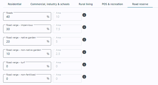
Figure 4-6: Road reserve tab from the UNDO tool’s land-use configuration panel
Input summary charts
Charts for the nutrient inputs from each of the subregions are shown in a panel on the far left of the UNDO tool’s input page (if the screen resolution is low or the tool interface is not maximised, the user may need to scroll left to view the charts). An example of the charts for subregions is shown in Figure 4-1.
The charts are immediately updated when changes are made on the input page. The charts will switch from reporting in absolute load (kg/yr) to relative load (kg/ha/yr) when the load reporting unit toggle button (located on the UNDO tool command bar) is clicked.
The charts provide the user with a clear visual comparison of the subregions that are producing the largest loads and will help target subregions for treatment or remediation, and provide better understanding of the development’s nutrient inputs.
Error reporting
The UNDO tool’s input page provides error reporting functionality. This ensures that:
- The sum of all subregions is equal to the development area.
- The sum of all land-use types for a particular subregion is equal to the total area of the subregion.
- The sum of the land-use components within a land-use type is equal to the area of that particular land-use type.
An example of the error reporting functionality is displayed in Figure 4-8.
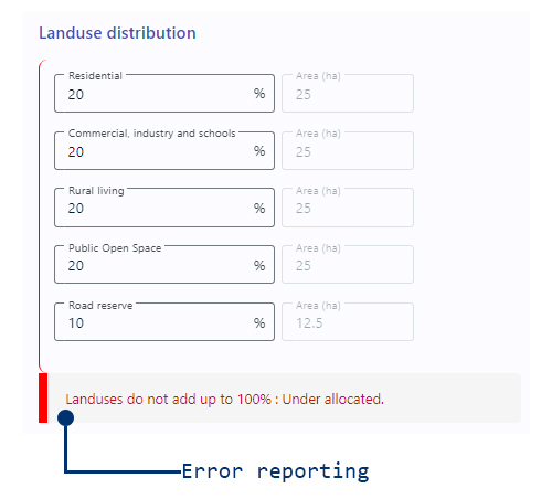
Figure 4-8: Example of the UNDO tool error reporting on the input page
The error reporting provides a list of the errors, which includes the name of the subregion (Subregion 1 in the example above), where the error occurs, and the quantity of the error. In the example above, the land-use types are 'under-allocated’, so the user hasn't put a land use types that total to 100% of the subregion area.